Public Comment for Planning Commission Items

- Below is a list of the public hearing items
- They include a brief explanation
- Click on them if you would like to leave a comment
- You may leave comments and read others comments. BE RESPECTFUL
- You may also ask questions about the projects to Staff
NOTE: You must register to leave a public comment. All it takes is a quick registration (2-3 minutes).
-
SOA Plat 1 Preliminary Subdivision
Share SOA Plat 1 Preliminary Subdivision on Facebook Share SOA Plat 1 Preliminary Subdivision on Twitter Share SOA Plat 1 Preliminary Subdivision on Linkedin Email SOA Plat 1 Preliminary Subdivision linkHoward Cooke is proposing the SOA Plat 1 preliminary subdivision located at Blue Sky Road and Orinda Drive. This proposed subdivision will include four commercial lots and a road connection to extend Blue Sky Road to Orinda Drive. The extension of Blue Sky Road is consistent with the connectivity and block length requirements listed in Chapter 37 of the Development Code. Blue Sky Road is proposed to include a 5-foot sidewalk and 7-foot planter to meet our City standard.

-
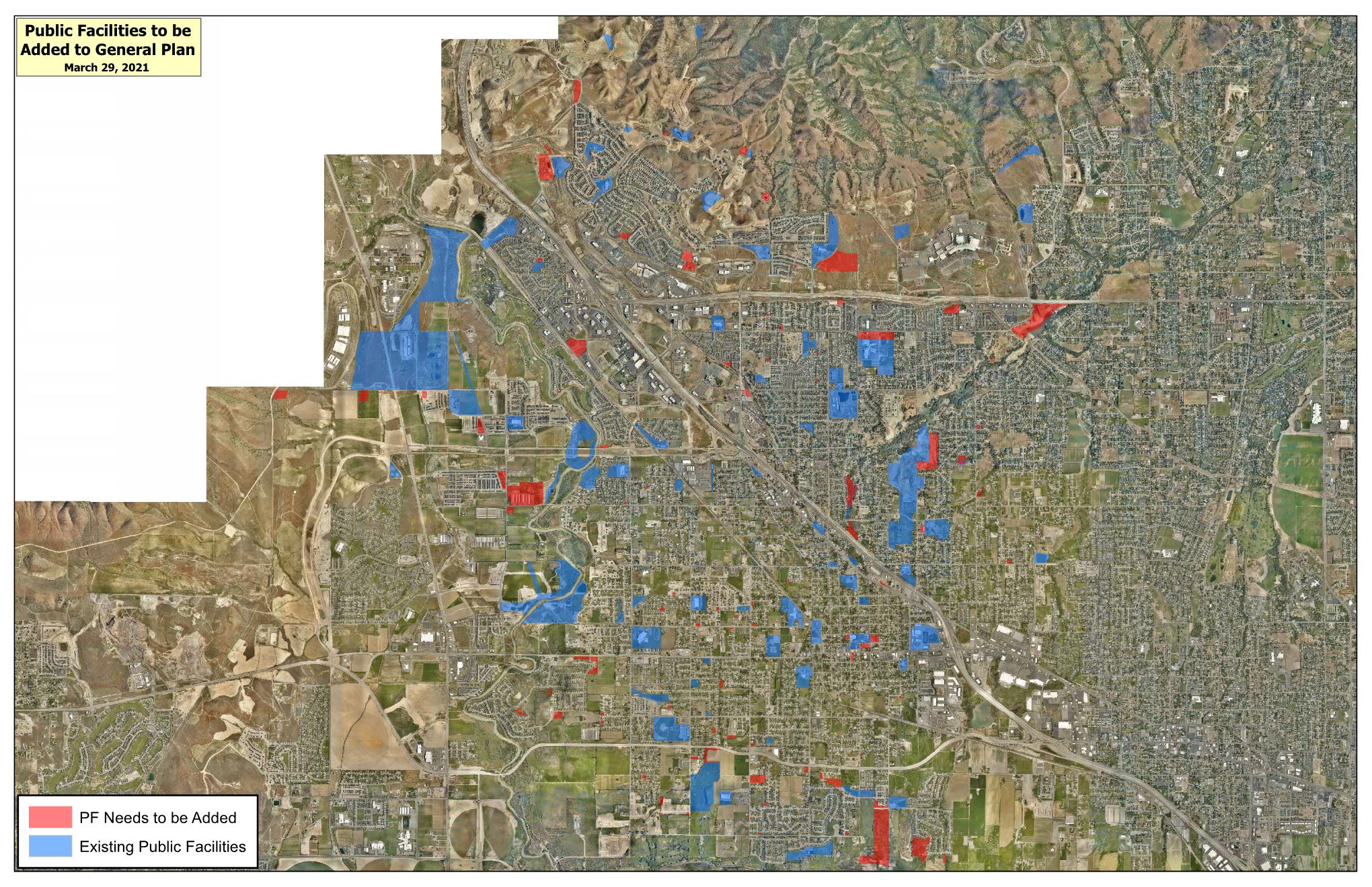
Lehi City Public Facilities General Plan Amendment
Share Lehi City Public Facilities General Plan Amendment on Facebook Share Lehi City Public Facilities General Plan Amendment on Twitter Share Lehi City Public Facilities General Plan Amendment on Linkedin Email Lehi City Public Facilities General Plan Amendment linkLehi City is proposing to change several City owned and Alpine School District owned properties from their current General Plan designations to the Public Facilities designation. The City is required to provide public notice to property owners within 300 feet of a change to the General Plan. The map below shows the locations of both existing Public Facility designations (in blue) and proposed (in red).
The Public Facilities designation is meant to ensure and protect the long-term public use of public property. Common uses in the Public Facility District include, but are not limited to parks, trails, public schools, city buildings, city parking lots, and city public utility buildings such as water tanks and power substations. Additionally, changing the designation makes it simpler for both City Staff and residents to identify these facilities on the General Plan and Zoning maps.
The Planning Commission will be holding a public hearing on this item in-person on May 27th at 7 pm at City Hall.
If you would like to leave an official pubic comment, please do so below.
-
Bike and Ped Master Plan Map Updates
Share Bike and Ped Master Plan Map Updates on Facebook Share Bike and Ped Master Plan Map Updates on Twitter Share Bike and Ped Master Plan Map Updates on Linkedin Email Bike and Ped Master Plan Map Updates linkLehi City proposes updates to the Bike and Pedestrian Master Plan Maps showing updates to the planned infrastructure.

-
Family Park General Plan Amendment
Share Family Park General Plan Amendment on Facebook Share Family Park General Plan Amendment on Twitter Share Family Park General Plan Amendment on Linkedin Email Family Park General Plan Amendment linkLehi City wants to change a small section of Family Park from Public Facility to Low Density Residential (LDR) . This will allow for approximately eight single family lots the City can sell.
The City had to purchase land to connect 600 East between Airport Drive and Dry Creek. The creation of these residential lots to sell will pay for the land that was purchased for the road.
The General Plan Amendment is the first step in the process of getting these lots created. If the General Plan Amendment is approved, a zone change will follow, and then a preliminary and final subdivision.

You can leave an official public comment that will be shared at Planning Commission meeting.
You can also ask any questions about this General Plan Amendment.
-
Dimock Property Preliminary Subdivision
Share Dimock Property Preliminary Subdivision on Facebook Share Dimock Property Preliminary Subdivision on Twitter Share Dimock Property Preliminary Subdivision on Linkedin Email Dimock Property Preliminary Subdivision link
The Dimock Property subdivision is a 6-lot residential subdivision located at approximately 2300 West 700 North. This will be a cul-de-sac with half acre lot properties and the applicant will be making offsite roadway improvements to 2300 West along the property line.
-
Barney 8-Foot Fence Conditional Use
Share Barney 8-Foot Fence Conditional Use on Facebook Share Barney 8-Foot Fence Conditional Use on Twitter Share Barney 8-Foot Fence Conditional Use on Linkedin Email Barney 8-Foot Fence Conditional Use link
Request for approval of a conditional use permit for an 8-foot fence located at 428 South 640 West. The request comes because the applicant would like to increase privacy and security for the property. The Development Code requires that a conditional use permit be approved by the Planning Commission for any fencing greater than six feet.
-
Micron Area Plan Concept (Amendment)
Share Micron Area Plan Concept (Amendment) on Facebook Share Micron Area Plan Concept (Amendment) on Twitter Share Micron Area Plan Concept (Amendment) on Linkedin Email Micron Area Plan Concept (Amendment) link
D R Horton proposes an amendment to the existing Micron Area Plan. This concept shows a variety of land uses including different residential areas, mixed-use, parks and civic/church sites. It also shows an overall network of roads and trails. This represents a high level plan for future development and does not include all the details.They show an overall density of 2, 412 ERUs (equivalent residential units) which does for the most part represent residential housing but also some of the commercial spaces in the Mixed Use Area.
This concept plan is the first step in amending the Micron Area Plan. If approved, this concept will become their Land Use Map and regulate future development similarly to zoning. The other amendments that will follow will update things like the allowed uses table, the bulk and intensity table, design standard requirements and other regulations for future development. All of these changes are reviewed by Staff, Planning Commission and then approved or denied by City Council.
Please feel free to ask questions here or call for more information. -
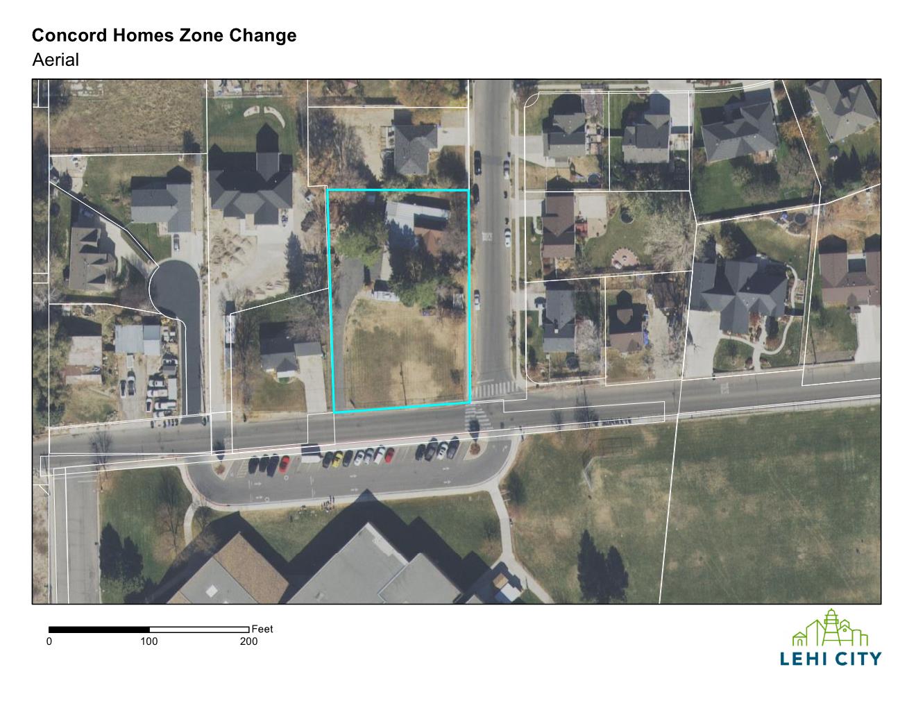
Concord Homes Zone Change
Share Concord Homes Zone Change on Facebook Share Concord Homes Zone Change on Twitter Share Concord Homes Zone Change on Linkedin Email Concord Homes Zone Change linkLocated at 705 East Cedar Hollow Road. Concord Homes wants to change the zoning on 0.69 acres from RA-1 to R-1-12. The RA-1 zones requires at least 15,000 square feet per lot. The R-1-12 zone requires at least 12,000 square feet per lot.
-
Crack Shack- Via 313 Site Plan
Share Crack Shack- Via 313 Site Plan on Facebook Share Crack Shack- Via 313 Site Plan on Twitter Share Crack Shack- Via 313 Site Plan on Linkedin Email Crack Shack- Via 313 Site Plan linkThe Crack Shack-Via 313 site plan is located at 1085 East Main Street between Fabulous Freddy’s Carwash that is under construction and the freeway on ramp. The plan consists of two separate restaurant buildings with a connected wall.
The Development Code requires 1 stall for every 2.5 seats as well as 0.5 spaces per employee on the largest shift. The applicant provided the seating for each restaurant totaling 171 and their max number of employees totaling 18. Based on these numbers they need 78 stalls and they provided 81.
The site also includes bicycle parking.


-
Bandwagon Plat A 2-Lot Subdivision
Share Bandwagon Plat A 2-Lot Subdivision on Facebook Share Bandwagon Plat A 2-Lot Subdivision on Twitter Share Bandwagon Plat A 2-Lot Subdivision on Linkedin Email Bandwagon Plat A 2-Lot Subdivision linkBen Card requests approval of Bandwagon Plat A, a 2-lot subdivision with an existing home located at 970 North 300 West. The area for the new lot is 15,675 square feet which meets the minimum lot size in the R-2 zone. The area for the existing home lot is approximately 9,391 square feet with 91 feet of frontage, which meets the requirements for the R-2 zone.


Planning Staff
-
Planner 3

Phone 385-201-2522 -
Planner 3
Phone 385-201-2516 -
Planner 2

Phone 385-201-2519